Contributed by Ryan Wheeler
What is now called Andover, North Andover, and parts of Lawrence, Massachusetts were once Cochichawick. This is the Indigenous name for the place where many of us work and live. The name persists in Lake Cochichewick in North Andover, Essex County’s largest lake. Indigenous leader Cutshamache transferred the land to English colonists, not through a deed, but rather in an agreement ultimately attested before the General Court of the Massachusetts Bay Colony:
At a General Court, at Boston 6th of the 3rd m, 1646 (in the Gregorian calendar, May 16, 1646)
Cutshamache, sagamore of the Massachusets, came into the Court, and acknowledged that for the sum of 6 pounds & a coat, which he had already received, he had sold to Mr. John Woodbridge, in behalf of the inhabitants of Cochichawick, now called Andover, all his right, interest, and privilege in the land six miles southward from the town, two miles eastward to Rowley bounds, be the same more or less, northward to Merrimack River, provided that the Indian called Roger & his company may have liberty to take alewifes in Cochichawick River, for their own eating; but if they either spoil or steal any corn or other fruit, to any considerable value, of the inhabitants there, this liberty of taking fish shall forever cease; and the said Roger is still to enjoy four acres of ground where now he plants. This purchase the Court allows of, and have granted the said land to belong to the said plantation forever, to be ordered and disposed of by them, reserving liberty to the Court to lay two miles square of their southerly bounds to any town or village that hereafter may be erected thereabouts, if so they see cause.
Cutshamache acknowledged this before the magistrates, and so the Court approved thereof, and of the rest in this bill to be recorded, so as it prejudice no former grant.
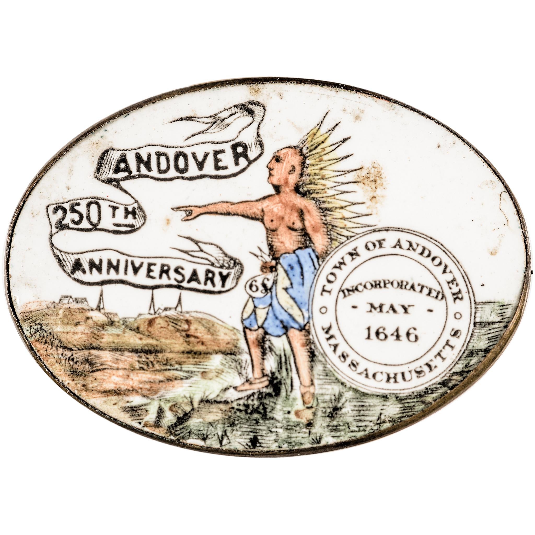
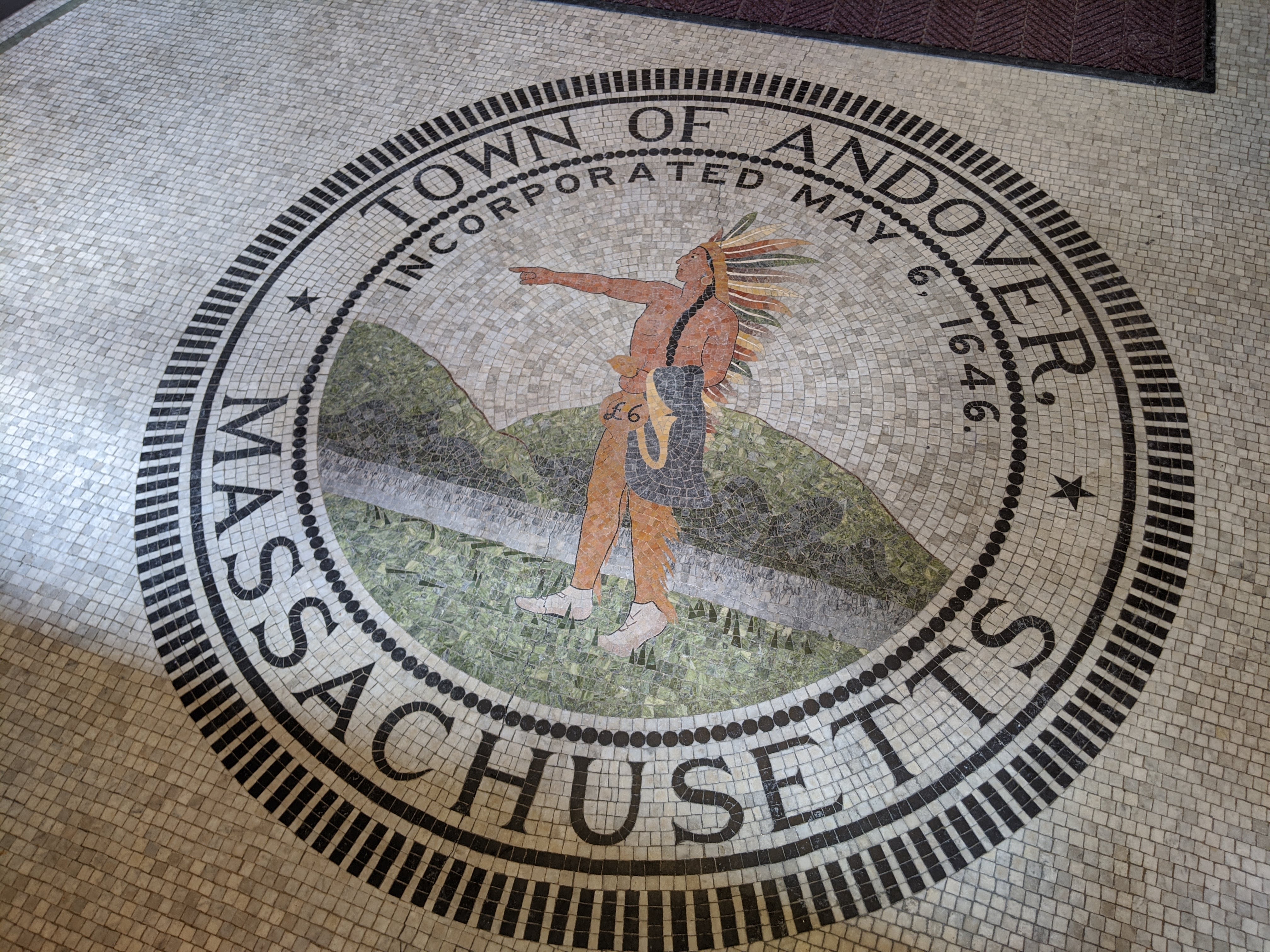
The story and its protagonist feature prominently in Andover’s 1895 town seal, where we see Cutshamache holding the coat, part of his payment for the land. Cutshamache appears frequently in the seventeenth century records of the English colony in Massachusetts, ranging from his involvement in the Pequot War to skepticism about missionary John Eliot’s preaching (see Drake 1856). Frank Speck (1928:141), in his discussion of the Punkapog Band of Massachusett, mentions that “the name and pronunciation of Kitchamakin or Cutshamekin are still remembered.” For us, his involvement in selling a large portion of Andover, North Andover, and Lawrence to John Woodbridge sometime in the early 1640s is of greatest interest. Local histories, in books, articles, and now online, frequently repeat the story, and tweak it to fit whatever narrative is being told. In some cases, the currency is converted into modern dollars (a pretty complicated exercise), and in other variants, Cutshamache is described as a Pennacook leader (see the Wikipedia entry for the Town of Andover). The latter makes sense, since the Pennacook, helmed by their leader Passaconaway, are associated with the area around Andover. However, Cutshamache does not appear to have been Pennacook, but was rather a Massachusett leader who lived in what is now Dorchester. The General Court statement clearly identifies him as such. But, this is puzzling, since Dorchester is pretty far from Andover. So what’s going on?
Many authors suggest a family connection between Passaconaway and Cutshamache, possibly based on Sidney Perley’s assertion (1912:35), though I have found no primary sources to support this and this suggested link may just be a way to help explain Cutshamache’s involvement in the sale of the Andover lands. Passaconaway does seem to have created alliances through marriage that crosscut ethnicity and relied more on cultural similarities, creating a heterogeneous coalition distinct from the more homogenous Massachusett (see Cook 1976:29; Stewart-Smith 1998:24-25). What’s more intriguing is the sale of Haverhill in 1642 by Native leaders Passaquo and Saggahew required the consent of Passaconaway (in fact, his consent is mentioned twice in the text of the deed). See the original document and transcript on the Essex National Heritage Area website. The General Court acknowledgment of the Andover, North Andover, and Lawrence sale does not mention Passaconaway, suggesting several possibilities. Perhaps Cutshamache’s less formal court appearance resulted in an omission. But, the court statement includes considerable detail, including the preservation of land and fishing rights for Roger and his company, Indigenous residents of the area.
Archaeologist Eric Johnson (1999:155), in his book chapter on Native political geography, provides a different way of thinking about Indigenous groups in the area during the seventeenth century that helps inform Cutshamache’s sale of Cochichawick. Johnson says, “What does a map of bounded tribes imply about political organization? It implies stasis and homogeneity, both within and among political units.” He attributes this to the desire of colonial European observers to describe unfamiliar people and places in a familiar way—through the lens of political organization in seventeenth century Europe. This plagues our understanding today—we want carefully delineated maps that show the boundaries of Indigenous lands, matching those of city, county, and state political entities. Johnson (1999:158) argues for a different model to understand the geography of the area that takes into account the dynamic and heterogeneous polities. Further, he suggests that groups in the region consisted of autonomous communities that regularly underwent expansion, contraction, and internal upheaval, depending on a variety of socio-political strategies at play among leaders and group members. Alliances, often transitory, could result in confederacies of autonomous groups, as well as splintering and new alliances. Confederations were based on real and fictive kinship relationships between principal leaders and those of local communities; autonomy of local communities varied greatly depending on the leadership qualities of the principal leader, overall group size, geographic distances between communities, and genealogical connections (Johnson 1999:161). Within this context, Kathleen Bragdon (2009:206-209), in her second book on the Native people of the Northeast, points to connections between Indigenous communities across the region, stating, “linkages between the Pennacooks and Pawtuckets of the Merrimac drainage of what is now northeastern Massachusetts and southern New Hampshire, show connections ranging as far south and east as Natick and Charlestown. Other historical evidence shows marriage ties between Pennacooks and Pawtuckets with Niantics and Wamesits as well.”
Intertribal relations just at the time of European conquest illustrate the linkages that likely characterize the area. After the devastating epidemic of 1619, Indigenous allies of the French raided the lower Merrimack. Passaconaway was the Pennacook sachem at the time. His Pawtucket counterpart, Nanepashemet, was killed around present-day Medford or Malden and his widow assumed the role of sachem. Two of her sons married Passaconaway’s daughters, cementing the Pennacook-Pawtucket alliance. According to historian David Stewart-Smith (1998:24-25), Passaconaway (also called Papisseconnewa) was acknowledged as the leader of Pawtucket, Agawam, and Piscataqua, though each group retained local leaders as well. He explains that it is helpful to think of the larger tribal designations as “aggregations of allied family territories,” including Pennacook, Pawtucket, Massachusett, Nipmuc, and others (Stewart-Smith 1998:28). The divisions were not hard lines, but rather fluctuated with marriages and other connections.

Historian Peter Leavenworth (1999:277) explains the ways in which Pennacook-Pawtucket lands moved into English ownership in the seventeenth century, principally through legal means, but also via violent incursions. He also documents important instances where Indigenous people resisted land loss. Leavenworth describes a violent attack against the Pennacook during King Philip’s War (1675-78), but helps us understand that the extensive transfers of land, through deeds or appearances in the General Court like Cutshamache’s, occurred during the 1640s, following the smallpox epidemic of 1633-34 and decisions by Passaconaway, including the belief that Indigenous people could share land with the English. According to Leavenworth (1999:281), there were serious misunderstandings in terms of what was happening, especially as these more informal land “sales” occurred: English colonists believed they were buying large tracts of land, while the Indigenous “sellers” believed they retained their usufruct rights. This is reflected in Cutshamache’s sale of Cochichawick, which references Roger and his group’s continuing rights to at least some small part of the landscape and fishing rights (check out this interactive map site that shows Rogers Brook in Andover, namesake of the seventeenth century Indigenous inhabitant). Leavenworth also documents an interesting shift in acceptable payment—at first the English were buying land for clothing, tools, ornaments and other trade goods, but apparently by 1650, the Indigenous people of the area would only accept currency. Cutshamache’s sale involves both—6 pounds in money, and a coat (interestingly, an earlier order by the General Court in 1642 directed that a coat be given to Cutshamache, perhaps the coat referenced in the 1646 appearance?).
So, there’s a lot to unpack in Cutshamache’s sale of Cochichawick. Most notable are the traditional cultural patterns that involved seasonal movements, settlement, and marriage that linked widely dispersed groups versus our modern desire to have Indigenous people fit into neat territories that align with historical and modern municipal, county, state, and national boundaries. It’s also impossible to think about this outside the devastating disruptions wrought by European incursions and the attendant diseases and demographic shifts (Strobel 2020:71-75). For example, Daniel Gookin, one of the English colonists, recorded 3,000 Pawtucket men in the earliest days of European conquest, but by 1674, the tribe had been reduced to “not above 250 men.” Within this milieu—traditional Indigenous practices, the disease and disruptions brought by the English, and attempts to adapt—land moved from Native to European hands.
For an Indigenous perspective, check out the detailed histories, timelines, and more on the Massachusett Tribe at Ponkapoag’s website. Here you can learn about the modern day Massachusett, their history, as well as ongoing initiatives, like work on the newly created Massachusetts state seal commission. If you would like to learn more about the Abenaki tribes in nearby New Hampshire and Vermont, start with the website of the Cowasuck Band of the Pennacook-Abenaki. There you can learn about history and contemporary initiatives of the Abenaki, who have close ties to the Native inhabitants of the Andover area.
References Cited and Further Reading
Bragdon, Kathleen J.
2009 Native People of Southern New England 1650 – 1775. University of Oklahoma Press, Norman.
Cook, Sherburne F.
1976 The Indian Population of New England in the Seventeenth Century. University of California Publications in Anthropology Vol. 12. University of California Press, Berkeley.
Drake, Samuel G.
1856 Biography and History of the Indians of North America, from its first discovery. Sanborn, Carter, and Bazin, Boston.
Johnson, Eric S.
1999 Community and Confederation: A Political Geography of Contact Period Southern New England. In The Archaeological Northeast, edited by Mary Ann Levine, Kenneth E. Sassaman, and Michael S. Nassaney, pp. 155-168. Bergin & Garvey, Westport, CT.
Leavenworth, Peter S.
1999 “The Best Title That Indians Can Claime:” Native Agency and Consent in the Transferal of Penacook-Pawtucket Land in the Seventeenth Century. The New England Quarterly 72(2):275-300.
Perley, Sidney
1912 Indian Land Titles, Essex County, Massachusetts. Riverside Press, Cambridge (for Essex Book and Print Club).
Speck, Frank G.
1928 Territorial Subdivisions of the Wampanoag, Massachusett, and Nauset Indians. Indian Notes and Monographs No. 44. Museum of the American Indian, Heye Foundation, New York.
Stewart-Smith, David
1998 The Pennacook Indians and the New England Frontier, circa 1604 – 1733. PhD dissertation, Union Institute, Cincinnati OH.
Strobel, Christoph
2020 Native Americans of New England. Praeger, Santa Barbara CA.
